BasinMaker developer documentation
BasinMaker - postprocessing tools
Extract the region of interest
- basinmaker.basinmaker.postprocess.Select_Subregion_Of_Routing_Structure(path_output_folder, routing_product_folder, gis_platform, most_down_stream_subbasin_ids=[], most_up_stream_subbasin_ids=[])
Select subregion of hydrologic routing network based on provided subbasin IDs
- Parameters:
path_output_folder (string) – is the folder path that stores generated outputs
routing_product_folder (string) – is the folder path where the input hydrologic routing network is stored
gis_platform (string) – is the parameter indicating which gis platform is used. It can be either “qgis” or “arcgis”.
most_down_stream_subbasin_ids (list) – A list of subbasin ID, the subbasin IDs in this list should be the most downstream subbasin ID of each interested watershed.
most_up_stream_subbasin_ids (list) – A list of subbasin ID, the subbasins that drainage to the SubID in this list will be excluded. Value [-1] is required to indicate no upstream subbasin needs to be removed.
Notes
This function has no return values, The extracted hydrological routing network will be generated in the path_output_folder including following files:
- finalcat_info.shpshapefile
The finalized hydrologic routing network. the GIS layer containing subbasin polygons which respect the lake inflow and outflow routing structures. This layer contains all the necessary information for hydrologic routing through the lake-river network.
- finalcat_info_riv.shpshapefile
The finalized hydrologic routing network. the GIS layer containing river network polylines in the routing network.
- catchment_without_merging_lakes.shpshapefile
The GIS layer containing subbasin polygons of an incomplete hydrologic routing network. In this incomplete hydrologic routing network subbasin polygons covered by the same lake are not merged into one lake subbasin yet. This incomplete hydrologic routing network is only intended as input to customize the routing network with our BasinMaker GIS toolbox (for example by defining new lake area thresholds and/or a new catchment minimum drainage area threshold)
- river_without_merging_lakes.shpshapefile
The GIS layer containing river polylines of an incomplete hydrologic routing network. In this incomplete hydrologic routing network, the river polylines covered by the same lake are not merged into one river segment yet. This incomplete hydrologic routing network is only intended as input to customize the routing network with our BasinMaker GIS toolbox (for example by defining new lake area thresholds and/or a new catchment minimum drainage area threshold)
- sl_connected_lake.shpshapefile
the GIS layer containing the lake polygons of lakes that are connected by the river_without_merging_lakes.shp
- sl_non_connected_lake.shpshapefile
the GIS layer containing the lake polygons of lakes that are not connected by the river_without_merging_lakes.shp
- poishapefile
It is the point shapefile that represent the point of interest after snap to river network.
Examples
Filter lakes
- basinmaker.basinmaker.postprocess.Remove_Small_Lakes(path_output_folder, routing_product_folder, gis_platform, connected_lake_area_thresthold=-1, non_connected_lake_area_thresthold=-1, selected_lake_ids=[], area_thresthold=0.009)
This function is to simplify the hydrologic routing network by removing lakes.
- Parameters:
path_output_folder (string) – is the folder path that stores generated outputs
routing_product_folder (string) – is the folder path where the input hydrologic routing network is stored
gis_platform (string) – is the parameter indicating which gis platform is used. It can be either “qgis” or “arcgis”.
connected_lake_area_thresthold (float (optional)) – is a lake area thresthold for connected lakes in km2. Connected lake with lake area below which lake will be removed
non_connected_lake_area_thresthold (float (optional)) – is a lake area thresthold for non-connected lakes in km2 Non connected lake with lake area below below which lake will be removed
selected_lake_ids (list (optional)) – A list of lake IDs from in the hydrologic routing network (Column ‘HyLakeId’). Lakes with their lake ID in this list will be kept by the BasinMaker even if their area smaller than the lake area threstholds
area_thresthold (float (optional)) – This parameter sets a subbasin area threshold in square kilometers (km²). Subbasins with an area below this threshold will be merged with downstream or upstream subbasins, depending on their location within the river network. This can be useful for simplifying the river network and reducing computational requirements. The parameter is optional and has a default value of 0.009 km2. If the parameter is set to 0, no subbasin merging will be performed.
Notes
This function has no return values, The simplified hydrological routing network will be generated in the path_output_folder including following files:
- finalcat_info.shpshapefile
The finalized hydrologic routing network. the GIS layer containing subbasin polygons which respect the lake inflow and outflow routing structures. This layer contains all the necessary information for hydrologic routing through the lake-river network.
- finalcat_info_riv.shpshapefile
The finalized hydrologic routing network. the GIS layer containing river network polylines in the routing network.
- catchment_without_merging_lakes.shpshapefile
The GIS layer containing subbasin polygons of an incomplete hydrologic routing network. In this incomplete hydrologic routing network subbasin polygons covered by the same lake are not merged into one lake subbasin yet. This incomplete hydrologic routing network is only intended as input to customize the routing network with our BasinMaker GIS toolbox (for example by defining new lake area thresholds and/or a new catchment minimum drainage area threshold)
- river_without_merging_lakes.shpshapefile
The GIS layer containing river polylines of an incomplete hydrologic routing network. In this incomplete hydrologic routing network, the river polylines covered by the same lake are not merged into one river segment yet. This incomplete hydrologic routing network is only intended as input to customize the routing network with our BasinMaker GIS toolbox (for example by defining new lake area thresholds and/or a new catchment minimum drainage area threshold)
- sl_connected_lake.shpshapefile
the GIS layer containing the lake polygons of lakes that are connected by the river_without_merging_lakes.shp
- sl_non_connected_lake.shpshapefile
the GIS layer containing the lake polygons of lakes that are not connected by the river_without_merging_lakes.shp
- poishapefile
It is the point shapefile that represent the point of interest after snap to river network.
Examples
Increase catchment area
- basinmaker.basinmaker.postprocess.Decrease_River_Network_Resolution(path_output_folder, routing_product_folder, gis_platform, minimum_subbasin_drainage_area, area_thresthold)
This function is to simplify the hydrologic routing network by removing subbasins/river reaches with their drainage area below user provided drainage area thresthold.
- Parameters:
path_output_folder (string) – is the folder path that stores generated outputs
routing_product_folder (string) – is the folder path where the input hydrologic routing network is stored
gis_platform (string) – is the parameter indicating which gis platform is used. It can be either “qgis” or “arcgis”.
minimum_subbasin_drainage_area (float) – is a subbasin drainage area thresthold, subbasin with their drainage area smaller than this thresthold will be removed.
area_thresthold (float (optional)) – This parameter sets a subbasin area threshold in square kilometers (km²). Subbasins with an area below this threshold will be merged with downstream or upstream subbasins, depending on their location within the river network. This can be useful for simplifying the river network and reducing computational requirements. The parameter is optional and has a default value of 0.009 km2. If the parameter is set to 0, no subbasin merging will be performed.
Notes
This function has no return values, The simplified hydrological routing network will be generated in the path_output_folder including following files:
- finalcat_info.shpshapefile
The finalized hydrologic routing network. the GIS layer containing subbasin polygons which respect the lake inflow and outflow routing structures. This layer contains all the necessary information for hydrologic routing through the lake-river network.
- finalcat_info_riv.shpshapefile
The finalized hydrologic routing network. the GIS layer containing river network polylines in the routing network.
- catchment_without_merging_lakes.shpshapefile
The GIS layer containing subbasin polygons of an incomplete hydrologic routing network. In this incomplete hydrologic routing network subbasin polygons covered by the same lake are not merged into one lake subbasin yet. This incomplete hydrologic routing network is only intended as input to customize the routing network with our BasinMaker GIS toolbox (for example by defining new lake area thresholds and/or a new catchment minimum drainage area threshold)
- river_without_merging_lakes.shpshapefile
The GIS layer containing river polylines of an incomplete hydrologic routing network. In this incomplete hydrologic routing network, the river polylines covered by the same lake are not merged into one river segment yet. This incomplete hydrologic routing network is only intended as input to customize the routing network with our BasinMaker GIS toolbox (for example by defining new lake area thresholds and/or a new catchment minimum drainage area threshold)
- sl_connected_lake.shpshapefile
the GIS layer containing the lake polygons of lakes that are connected by the river_without_merging_lakes.shp
- sl_non_connected_lake.shpshapefile
the GIS layer containing the lake polygons of lakes that are not connected by the river_without_merging_lakes.shp
- poishapefile
It is the point shapefile that represent the point of interest after snap to river network.
Examples
Modify point of interest in the routing product
- basinmaker.basinmaker.postprocess.Add_Point_Of_Interest_Sites_In_Routing_Product(path_output_folder, routing_product_folder, gis_platform, clean_exist_pois, area_thresthold)
This function allows the user to modify point of interest (POI) sites in a pre-existing BasinMaker-generated user input hydrologic routing network/product. Specific modifications this function can make are to add new POI sites, remove existing POI sites, or modify the location of existing POI sites in the input routing network. This function will use the location of the provided POI and link them to the subbasins in the routing network. At least one POI should be provided in the point shapefile.
- Parameters:
path_output_folder (string) – is the folder path that stores generated outputs
routing_product_folder (string) – is the folder path where the input hydrologic routing network is stored
path_to_points_of_interest_points (string) –
is the path to the point shapefile that contains the point of interest (POI) sites. The shapefile must have an attribute table that includes the following columns:
Obs_NM (string): This column should contain the name or ID of the POI site. When the provided POI has the same Obs_NM as the existing POI in the routing product, this function will assume that the user wants to relocate the existing POI. Otherwise, the clean_exist_pois variable below controls whether the new POI sites fully replace existing POI sites or augment the existing POI sites.
DA_Obs (float): This column should contain the drainage area of the POI site.
SRC_obs (string): This column should contain the source of the POI site.
Type (string): This column should contain the type of the POI site. Each POI can only have one type. The following types are currently supported: “Lake”: the POI is located on a lake waterbody surface. “River”: the POI is located on a river channel. Note that the “Lake” type POI should be located within a lake subbasin and the “River” type POI should be located within a non-lake subbasin. The POI located in the wrong subbasin will be ignored and not added to the routing product. The “River” type POI will be linked to a non-lake subbasin that contains the POI. The “Lake” type POI will be linked to the lake subbasin that contains the POI.
gis_platform (string) – is the parameter indicating which gis platform is used. Currenly, only “purepy” is allowed for this parameter.
clean_exist_pois (boolean) – Indicates if the user wants to remove all existing POI in the input routing product. When it is true, all existing POI will be removed, and only the POI sites provided in the path_to_points_of_interest_points will be added to the input routing network.
Notes
This function does not return any values. If the user only wants to add POI to the routing product, they should set clean_exist_pois to False. This will keep the existing POI and add the provided POI to the routing product. If the user wants to remove all existing POI and add new POI, they should set clean_exist_pois to True. This will remove all existing POI from the routing product and then add the provided POI to the routing product. The modified hydrological routing network will be generated in the path_output_folder and will include the following files:
- finalcat_info.shpshapefile
The finalized hydrologic routing network. the GIS layer containing subbasin polygons which respect the lake inflow and outflow routing structures. This layer contains all the necessary information for hydrologic routing through the lake-river network.
- finalcat_info_riv.shpshapefile
The finalized hydrologic routing network. the GIS layer containing river network polylines in the routing network.
- catchment_without_merging_lakes.shpshapefile
The GIS layer containing subbasin polygons of an incomplete hydrologic routing network. In this incomplete hydrologic routing network subbasin polygons covered by the same lake are not merged into one lake subbasin yet. This incomplete hydrologic routing network is only intended as input to customize the routing network with our BasinMaker GIS toolbox (for example by defining new lake area thresholds and/or a new catchment minimum drainage area threshold)
- river_without_merging_lakes.shpshapefile
The GIS layer containing river polylines of an incomplete hydrologic routing network. In this incomplete hydrologic routing network, the river polylines covered by the same lake are not merged into one river segment yet. This incomplete hydrologic routing network is only intended as input to customize the routing network with our BasinMaker GIS toolbox (for example by defining new lake area thresholds and/or a new catchment minimum drainage area threshold)
- sl_connected_lake.shpshapefile
the GIS layer containing the lake polygons of lakes that are connected by the river_without_merging_lakes.shp
- sl_non_connected_lake.shpshapefile
the GIS layer containing the lake polygons of lakes that are not connected by the river_without_merging_lakes.shp
- poishapefile
It is the point shapefile that represent the point of interest after snap to river network.
Examples
Generate HRUs
- basinmaker.basinmaker.postprocess.Generate_HRUs(path_output_folder, gis_platform, path_subbasin_polygon, path_landuse_info, path_soil_info, path_veg_info, prjected_epsg_code='EPSG:3573', path_connect_lake_polygon='#', path_non_connect_lake_polygon='#', path_landuse_polygon='#', path_soil_polygon='#', path_vegetation_polygon='#', path_other_polygon_1='#', area_ratio_thresholds=[0, 0, 0], path_to_dem='#')
This function is to generate HRU map based on subbasin polygon, lake polygon (optional), Land use polygon (optional), soil type polygon(optional), vegetation polygon (optional), and two other user defined polygons (optional).
- Parameters:
path_output_folder (string) – is the folder path that stores generated outputs
gis_platform (string) – is the parameter indicating which gis platform is used. It can be either “qgis” or “arcgis”.
path_subbasin_polygon (string) – is the path of the subbasin polygon, which is generated by BasinMaker.
path_landuse_info (string) –
Path to a csv file that contains landuse information, including the following attributes:
Landuse_ID (integer) – the landuse ID in the landuse polygon,-1 for lakeLAND_USE_C (string) – the landuse class name for each landuse typepath_soil_info (string) –
is the path to a csv file that contains soil information, including following attributes:
Soil_ID (integer) – the soil ID in the soil polygon,-1 for lakeSOIL_PROF (string) – the soil profile name for each soil profile typepath_veg_info (string) –
is the path to a csv file that contains vegetation information, including following attributes:
Veg_ID (integer) – the vegetation ID in the vegetation polygon,-1 for lakeVEG_C (string) – the vegetation class name for each vegetation Typeprojected_epsg_code (string (optional)) – is a EPSG code to indicate a projected coordinate system. If the routing network generated by basinmaker is under a projected system, please assgin the EPSG code of that projected system to projected_epsg_code. If the routing network generated by basinmaker is under a geographic system, please use EPSG code from any projected system. The coordinate system of routing network from basinmaker is determined by the coordinate system of input DEM.
path_connect_lake_polygon (string (Optional)) – is the path to the connected lake’s polygon
path_non_connect_lake_polygon (string (Optional)) – is the path to the non connected lake’s polygon
path_landuse_polygon (string (Optional)) – is the path to the landuse polygon. when path_landuse_polygon is not provided. The Landuse ID in path_landuse_info should be 1: land, -1: lake
path_soil_polygon (string (Optional)) – is the path to the soil polygon. when soil polygon is not provided. The Soil ID in path_soil_info should be the same as Landuse ID.
path_vegetation_polygon (string (Optional)) – is the path to the vegetation polygon. when vegetation polygon is not provided. The Veg ID in path_veg_info should be the same as Landuse ID.
path_other_polygon_1 (string (Optional)) – is the path to the other polygon that will be used to define HRU, such as elevation band, or aspect.
DEM (string (optional)) – is the path to a raster elevation dataset, that is used to calcuate average apspect, elevation and slope within each HRU. if no data is provided, subbasin averaged value will be used for each HRU.
area_ratio_thresholds (list (optional)) – It is a list of HRU area thresthold for landuse, soil and other_1 layer respectively. In BasinMaker HRU calculation, each layer will firstly be overlaid to the subbasin map. Attributes falling into each subbasin with their area ratios (i.e., the intersected area to the subbasin area) smaller than the defined threshold values will then be dissolved into the largest part. For example, if forest area ratio in a subbasin, say subbasin #10, is 0.05, while we set the area threshold for land cover is 0.1. The forest polygons will then be dissolved to the largest land cover type in subbasin #10.
Notes
This function has no return values, but a HRU map saved in the path_output_folder
Examples
Generate Raven input files
- basinmaker.basinmaker.postprocess.Generate_Raven_Model_Inputs(path_output_folder, path_hru_polygon, aspect_from_gis, model_name='test', subbasingroup_nm_channel=['Allsubbasins'], subbasingroup_length_channel=[-1], subbasingroup_nm_lake=['AllLakesubbasins'], subbasingroup_area_lake=[-1])
This function is to generate Raven input files. A subfolder ‘RavenInput’ in path_output_folder is created to sotre resultant outputs.
- Parameters:
path_output_folder (string) – is the folder path that stores generated Raven input fiels
path_hru_polygon (string) – is path of the output HRU shapefile from BasinMaker which includes all required hydrologic attributes and parameters; Each row in the attribute table of this shapefile represent a HRU.
aspect_from_gis (string) – is a string indicating how aspect of each HRU in path_hru_polygon is caculated. “grass” represent the aspect is calcuated by GRASS GIS; “arcgis” represent the aspect is calcuated by ArcGIS.
model_name (string (optional)) – is the The Raven model base name.
subbasingroup_names_channel (list (optional)) – is a list of names for subbasin groups, which are grouped based on channel length of each subbsin. Should at least has one name
subbasingroup_length_channel (list (optional)) –
is a list of channel length thresthold in meter, that divides subbasin into different groups. For example, [1,10,20] divides subbasins into four groups:
1) group 1 with channel length range from (0,1];2) group 2 with channel length range from (1,10];3) group 3 with channel length range from (10,20];4) group 4 with channel length range from (20,Max channel length].subbasingroup_name_lake (list (optional)) – is a list of names for subbasin groups, which are grouped based on area of lakes in lake subbasins. Should at least has one name
subbasingroup_area_lake (list (optional)) –
is a list of lake area thresthold in m2, that divides subbasin into different groups. For example, [1,10,20] divides subbasins into four groups:
1) group 1 with lake area range from (0,1];2) group 2 with lake are range from (1,10],3) group 3 with lake are range from (10,20],4) group 4 with lake are range from (20,max_lake_area].
Notes
The following ouput files will be generated in “<path_output_folder>/RavenInput”
modelname.rvh - contains subbasins and HRUsLakes.rvh - contains definition and parameters of lakeschannel_properties.rvp - contains definition and parameters for channelsExamples
BasinMaker - delineate lake-river routing product tools
In order to fully delineate a lake-river routing network from scratch, users need to sequentially apply five BasinMaker functions (ND1 to ND5) described in this section.
The overview of the workflow is summarized in the Figure below.
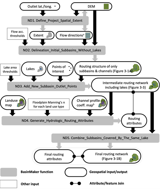
Figure Caption: This is Figure 3 from han et al. (2023). Workflow, including inputs and outputs, of the BasinMaker network delineation mode functions for generating a hydrological routing network with lakes and rivers given a DEM and a lake polygon layer. Notes: 1. Flow direction raster dataset is optional user input here. 2. The channel profile coefficient map to define bankfull channel widths and depths across the extent can alternatively be replaced by coefficients that are constant across the spatial extent of the project.
Define project spatial extent
- basinmaker.basinmaker.delineate.Define_Project_Spatial_Extent(mode, path_to_dem_input, watershed_outlet_coordinates=[-1, -1], path_to_spatial_extent_polygon='#', buffer_distance=0.0, path_to_hydrobasin_polygon='#', hydrobasin_id_of_watershed_outlet=-1)
This function is to define project spatial extent (PSE). Domain ouside of the PSE is not processed by BasinMaker functions.
- Parameters:
mode (string (required)) –
is a string indicating which to define PSE
’using_dem’ : the extent of input dem is used’using_hybasin’ : the extent is defined by subbasins that are drainage to the provided watershed outlet subbasins ID in HydroBASINS product’using_outlet_pt’ : the extent is defined by the watershed generated from input dem and the watershed outlet coordinates’using_provided_ply’ : the extent of provided polygon is usedpath_to_dem_input (string (required)) – is the path to input dem
watershed_outlet_coordinates (list (optional)) – is a list that indicate the outlet coordinates of the region of interest in [lat, lon]. It is needed when mode = ‘using_outlet_pt’.
path_to_spatial_extent_polygon (string (optional)) – is the path of a polygon shapefile, the extent of which will be used as PSE.
buffer_distance (float (optional)) – is a float number to enlarge the PSE. It is needed when mode = ‘using_hybasin’ or mode = ‘using_provided_ply’. It is the distance around the PSE from HydroBASINS or provided polygons that will be buffered. The unit is the same with the spatial unit of input DEM.
path_to_hydrobasin_polygon (string (optional)) – is a path to the HydroBASINs product. It is needed when mode = ‘using_hybasin’
hydrobasin_id_of_watershed_outlet (int (optional)) – is a HydroBASINS subbasin ID of the watershed outlet. It is needed when mode = ‘using_hybasin’
Notes
Outputs are following files in GRASS GIS database loacated in os.path.join(path_working_folder,’grassdb’)
- MASK.*raster/shp
it is a mask raster stored in grass database, which indicate the PSE.
- dem.*raster/shp
it is a dem raster stored in grass database, which is has the same extent with MASK.
Examples
Delineate routing structure without lakes
- basinmaker.basinmaker.delineate.Delineation_Initial_Subbasins_Without_Lakes(fac_thresold, mode='using_dem', path_flow_dirction_in='#', max_memroy=4096)
Function that used to generate a initial routing structure with user provied flow accumulation thresthold without considering lake.
- Parameters:
fac_thresold (float) – is the flow accumulation thresthold, used to determine subbsains and river network. Increasing of this paramter will increase the size of generated subbasins, reduce the number subbasins and reduce the number of generated stream reaches
mode (string (required)) –
is a string indicate which dataset will be used to delineate watershed.
’using_dem’ : dem is used for initial subbasin delineation’using_fdr’ : flow direction data is used for subbasin delineationpath_flow_dirction (string (optional)) – is a path indicating the path of flow direction input dataset only needed when mode = ‘using_fdr’
max_memroy (integer) – is the maximum memeory that allow to be used in MB.
Notes
Outputs are following files in GRASS GIS database loacated in os.path.join(path_working_folder,’grassdb’)
- fdr_grassraster
is a raster represent flow direction dataset, which is using 1 - 8 to represent different directions
- fdr_arcgisraster
is a raster represent flow direction dataset, which is using 1,2,4,…64,128 to represent different directions
- str_vvector
is a river network in vector format
- str_rraster
is a river network in raster format
- cat_no_lakeraster
is the raster represent the delineated subbasins without considering lakes
- accraster
is the raster represent the flow accumulation
Examples
Add lake control points and points of interest
- basinmaker.basinmaker.delineate.Add_New_Subbasin_Outlet_Points(path_lake_polygon='#', lake_attributes=[], connected_lake_area_thresthold=0, non_connected_lake_area_thresthold=0, path_point_of_interest='#', point_of_interest_attributes=[], max_memroy=4096)
Update the subbasin delineation result by adding lake inflow and outflow points and observation gauges as a new subbasin outlets. The output is not the final delineation result. because:
1) Hydrologcial related attributes for each subbasin are not calcuated yet.2) Some lakes may cover several subbasins. The output needs to be finalized by combing those subbasins with the same lake as one subbasin only.- Parameters:
path_lake_polygon (string (optional)) – is a path of the lake polygon shapefile
lake_attributes (list (optional)) –
the columns names in the input lake polygon that indicate following items (mandatory). It is needed only when path_lake_polygon_in is provided. Columns (2-4 in following list) in lake poylon can be fill with any number, when these infomation is not avaiable.
1) column name for the unique Id of each lake, datatype is integer2) column name for type of the lake, datatype is integer3) column name for the volume of lakes in km3, datatype is float4) column name for the average depth of lakes in m, datatype is float5) column name for the area of lakes in km2, datatype is floatconnected_lake_area_thresthold (float (optional)) – is a lake area thresthold for connected lakes in km2. Connected lake with lake area below this value will not be considerd
non_connected_lake_area_thresthold (float (optional)) – is a lake area thresthold for non-connected lakes in km2 Non connected lake with lake area below this value will not be considered
path_point_of_interest – is a path of the point shapefile that indicate points of interest,which can include different observation gauges.
point_of_interest_attributes (list (optional)) –
the columns names in the point of interest shapefile that indicate following items (mandatory). It is needed only when path_point_of_interest is provided. Columns (2-4 in following list) in point shapefile can be fill with any value, when these infomation is not avaiable.
1) column name for the unique Id of each observation point, datatype is integer2) column name for the unique name of each observation point, datatype is string3) column name for the drainage area of each observation point in km3, datatype is float4) column name for the source of the observation point: ‘CA’ for observation in canada; ‘US’ for observation in US, or any user-provided names, datatype is stringmax_memroy (integer (optional)) – is the maximum memeory that allow to be used in MB.
Notes
Output raster and vector files that will be used by next step are list as following. All files are saved in GRASS GIS database loacated in os.path.join(path_working_folder,’grassdb’)
- selected_lakesraster
it is a raster represent all lakes that are selected by two lake area threstholds
- sl_nonconnect_lakeraster
it is a raster represent all non connected lakes that are selected by lake area threstholds
- sl_connected_lakeraster
it is a raster represent all connected lakes that are selected by lake area threstholds
- river_without_merging_lakesraster/vector
it is the updated river segment for each subbasin
- catchment_without_merging_lakesraster/vector
it is a raster represent updated subbasins after adding lake inflow and outflow points as new subbasin outlet.
- snapped_obs_pointsraster/vector
it is a name of the point gis file represent successfully sanpped point of interest points
Examples
Guidance on Points of Interest input layer preparation
For those running BasinMaker with QGIS & GRASS, points of interest will be snapped by this function automatically to the closest delineated river channel and as such, no input layer preparation is strictly required. However, in our experience this auto-snapping approach is only modestly successful. Please inspect snapped results carefully. If users ensure that points of interest associated with lake levels are located within a lake polygon, then this function will include the point of interest at the lake (and lake subbasin) outlet.
For those running BasinMaker in ArcGIS pro, the user needs to carefully prepare the points of interest shapefile as input. Specifically, the location of each non-lake point of interest should be carefully snapped to the the appropriate eventual delineated river channel. To do this, we recommend users build a temporary channel raster and snap to that. We also recommend users ensure that points of interest associated with lake levels are located within a lake polygon. These POI will be ignored by this function and must be added separately from this function using the function called “Add_Point_Of_Interest_Sites_In_Routing_Product”.
A robust new function that can help users automatically snap points of interest to delineated river channels/lakes is coming in the next version of BasinMaker.
Combine catchment covered by the same lake
- basinmaker.basinmaker.delineate.Combine_Subbasins_Covered_by_The_Same_Lake(routing_product_folder, gis_platform='qgis')
Finalize a incomplete hydrologic routing network by merging subbasin polygons that are covered by the same lake.
- Parameters:
routing_product_folder (string) – is the folder where the input routing product is stored
gis_platform (string) – It is the parameter indicate which gis platform is used. It can be either “qgis” or “arcgis”.
Notes
This function has no return values, two vector files will be generated in the routing_product_folder
- finalcat_info.shpshapefile
The finalized hydrologic routing network. the GIS layer containing subbasin polygons which respect the lake inflow and outflow routing structures. This layer contains all the necessary information for hydrologic routing through the lake-river network.
- finalcat_info_riv.shpshapefile
The finalized hydrologic routing network. the GIS layer containing river network polylines in the routing network.
Examples